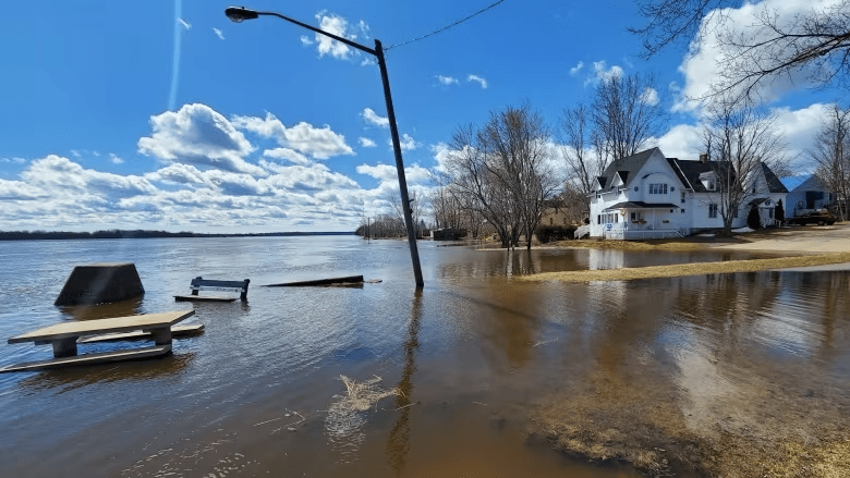
Water levels are beginning to rise in parts of New Brunswick, with two communities already under a water-level advisory and another one set to move to a watch by weekend, according to the province’s River Watch website.
An water-level advisory is two metres below flood stage, and a water-level watch is one metre below, according to the site.
Woodstock has been under a water-level advisory since at least March 14, said Geoffrey Downey, spokesperson for the Emergency Measures Organization. He said Woodstock always “floats around” the advisory stage at this time of year.
The River Watch program is an online platform that shows water levels in the St. John River, also known as the Wolastoq, and its tributaries.
Saint-Hilaire, now part of Haut-Madawaska, is forecast to be under an advisory by Thursday and at a watch level by Saturday.

Downey said once a community hits the watch stage, which is followed by warning and flood stages, “it’s a good indication that people really do need to be paying closer attention at that point.”
Gagetown just entered advisory territory on Tuesday, said Downey, but data for the rest of the week is not available. Information for later in the week also isn’t available for much of south and central New Brunswick.
“There’s not enough water flow yet going through Mactaquac to do a prediction or forecast for those spots. Once the river picks up, I believe … it’ll be later this week, there will be numbers for those spots on St. John River.”
- With flood season approaching, province launches annual River Watch
- River Watch 2022 ends with no major flooding but caution from EMO head
For Woodstock, Hartland, Simonds and Perth Andover, forecasts also are not available for the rest of the week because of “the unpredictable nature of ice jams.”
Downey said flooding from ice jams is harder to warn people about because as the ice starts breaking, it will start moving, which makes it more difficult to predict how much ice is going to break off, when it’s going to do it and where the ice jam will happen, if it does at all.
“We really count on the communities that have a history of extreme flooding to really start paying attention right now because it is starting to break up, temperatures are starting to rise,” said Downey. “So until all the ice is out, you can certainly count on that threat as well.”
He also warned that with the ice starting to break up, the river is considerably more dangerous than it was a couple of weeks ago.
Other communities, including Nashwaak and Edmundston, will likely see water-level advisories this week, according to River Watch. But Downey said the melt this year is “fairly normal.”
“This is all playing out as a very typical spring so far, with the warmer temperatures in the year in early April starting to melt the snow,” said Downey.
“It always starts in the north and works its way down.”
With files from Information Morning Fredericton
This story was originally published in CBC News on April 11, 2023.
